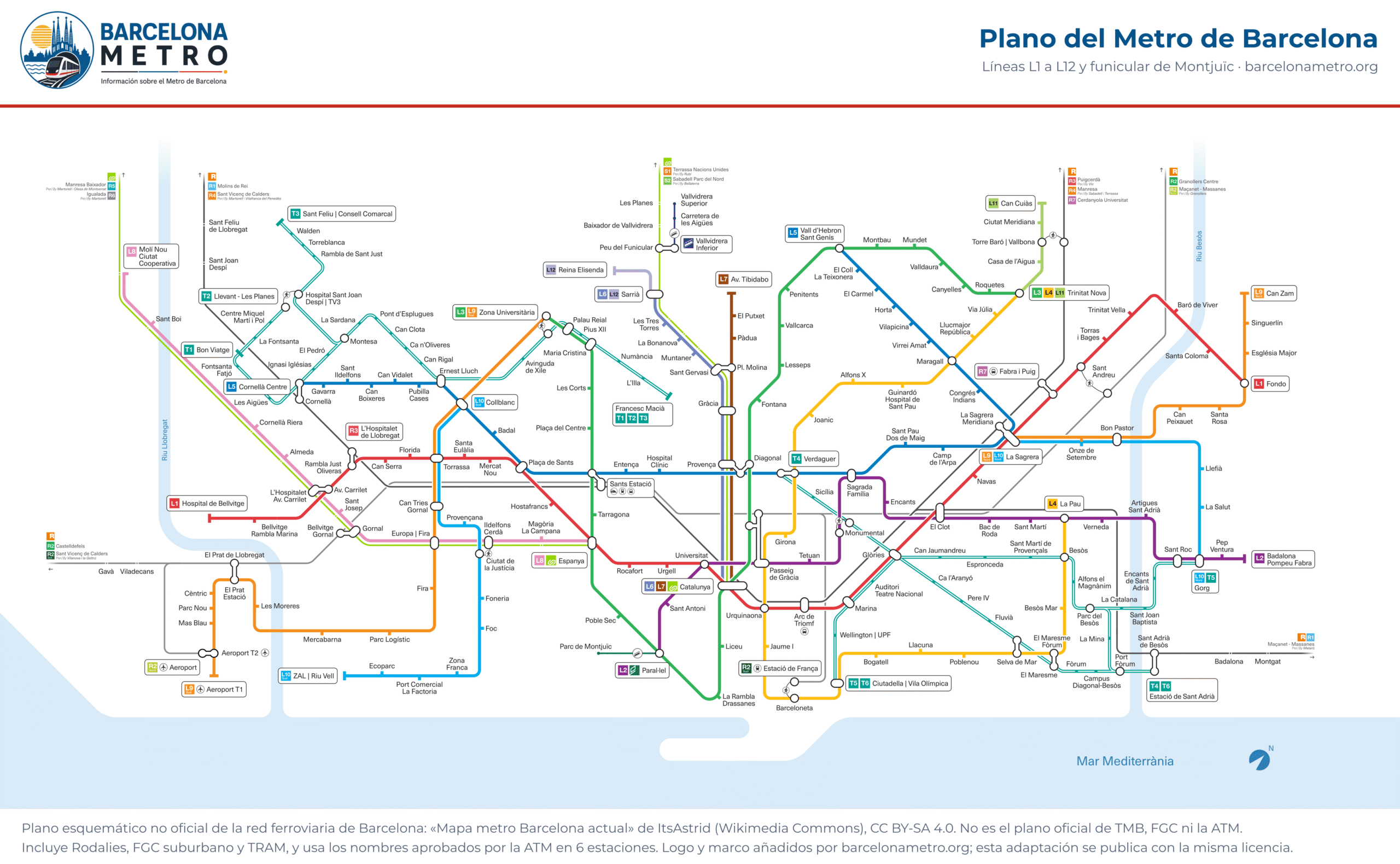
Barcelona metro map

Every TMB and FGC line and its stations on one map. Tap to enlarge it or download the PDF.

Barcelona metro map with lines L1 to L12 and the Montjuïc Funicular
Tap the map to see it full size. An unofficial schematic map of the rail network: the metro is lines L1 to L12 and the FM; it also shows Rodalies, the FGC suburban trains and the TRAM. “Mapa metro Barcelona actual” by ItsAstrid (Wikimedia Commons, CC BY-SA 4.0); frame and logo added by barcelonametro.org (same licence). This is not the official TMB, FGC or ATM map.

Metro map as a PDF

Barcelona metro map · PDF

Vector PDF: it stays sharp however much you zoom in. Save it on your phone for when you have no signal.

Download PDF

How to read the map

Each line has its own colour, the same one TMB and FGC use and the one you see on this website. It is a diagram, not a street map: distances are not to scale.

Some stations with different names are linked by interchange walkways: Av. CarriletES and L’Hospitalet Av. CarriletES, Ciutat de la JustíciaES and Ildefons CerdàES and Diagonal and ProvençaES. L9 and L10 share the track on two sections, between La Sagrera and Bon Pastor in the north and between Can Tries | Gornal and Collblanc in the south, but they are separate lines.

The map labels 6 stations with the names the ATM approved in 2022, which TMB does not yet use in its own information: “Bellvitge Rambla Marina” (BellvitgeES), “El Clot” (ClotES), “Congrés | Indians” (CongrésES), “La Rambla | Drassanes” (Drassanes), “Llucmajor | República” (LlucmajorES) and “Vall d’Hebron | Sant Genís” (Vall d’HebronES). This guide uses the operator’s names.

LineStationsRouteOperator
L130Hospital de Bellvitge – FondoTMB
L218Paral·lel – Badalona Pompeu FabraTMB
L326Zona Universitària – Trinitat NovaTMB
L422La Pau – Trinitat NovaTMB
L527Cornellà Centre – Vall d'HebronTMB
L9N9La Sagrera – Can ZamTMB
L9S15Aeroport T1 – Zona UniversitàriaTMB
L10N6La Sagrera – GorgTMB
L10S11ZAL | Riu Vell – CollblancTMB
L115Trinitat Nova – Can CuiàsTMB
L68Catalunya – SarriàFGC
L77Catalunya – Av. TibidaboFGC
L811Espanya – Molí Nou - Ciutat CooperativaFGC
L122Sarrià – Reina ElisendaFGC
FM2Paral·lel – Parc de MontjuïcTMB

Fare zones

All metro stations, TMB and FGC alike, are in the ATM’s zone 1, which also covers the towns in the metropolitan area that the metro reaches. With a one-zone ticket you can make any metro journey, except getting on or off at the airport stations, which have their own rules. Prices are on the Fares page.

Frequently asked questions

No. The official map belongs to TMB and the ATM and has no free licence. This is a schematic map published on Wikimedia Commons by ItsAstrid under a CC BY-SA 4.0 licence, showing the same lines and stations.
Yes. The PDF above is vector-based, and the image links to a large PNG. You can share them under the CC BY-SA 4.0 licence, crediting the author as shown in the map caption.
Because it shows the whole rail network: as well as the metro (L1 to L12 and the Montjuïc Funicular) it includes the Rodalies lines, the FGC suburban trains and the TRAM, with interchanges at many stations.